Epilogue #1

In my discombobulated state on the top of Moel Famau, I’d managed to lose sight of what I’d undertaken the walk for. On the summit, I’d tried to film a couple of ‘well, here I am’ monologues for the video that I might make documenting the walk, and I had come up with the line ‘it’s good to turn a nice idea into a reality’, as the sort of take-home message of the endeavour.

But that’s not quite right. On reflection it felt calculatedly underwhelming, to the point of being disingenous. And it hazes over the real motivations for the walk.

When I got back to Manchester, and back up to the flat, it was dark. But there was already something added to the experience of gazing out over the lights of Ardwick, past the lights of the cranes, and over shining Tameside to where the line of the Eastern edge of the Peak District would be.

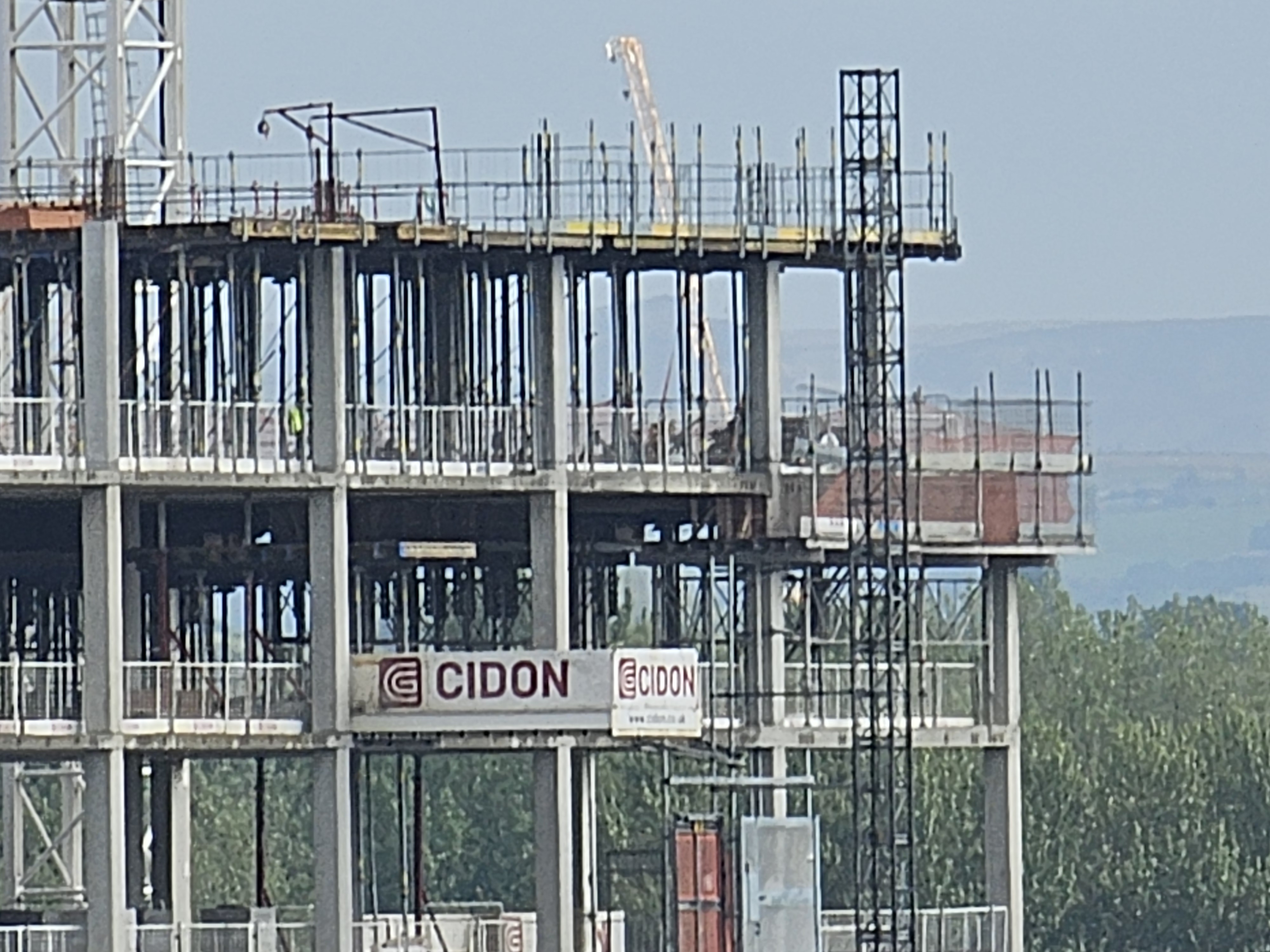
In the morning, it became clear that the walk’s timing had been spot on. The next floor had been added to the building that I knew was set to obscure Alderman’s Hill, and the line of sight linking it to my flat had finally been broken.

Alderman’s Farewell

At some point in the walk, the last piece of the rising framework would have been dropped into place in front of Alderman’s Hill. Maybe Friday, as I was heading out of England.

As soon as I saw the building was going up back early in 2026, a sort of desperation began in me. I’d already considered linking my long planned Moel Famau walk to something involving the Saddleworth skyline. I had versions of this which tried to trace every lick of hillside I could see from the kitchen window, combining parts of the ‘outer horizon’ I’d walked in 2016, with the ‘inner horizon’ – big features of the view but which were more towards the foreground – Wild Bank, Harridge Pike and the high ground up around Scouthead. So I’d do all that, then walk to the flat along the Medlock, and then head off to Wales.

I’d abandoned this after a few draft routes, because I was getting tangled up in my own rules and motivations – shifting the rules to include other notable features of the view from here added hours to the journey which didn’t seem likely to be that enjoyable to walk, that kind of thing.

But it had been fine to backburner this plan, because it was just something that would be cool to do at some point. Then with the building rising up and threatening sight of Alderman – I knew I didn’t have that luxury anymore.

And internally I was panicking. I didn’t want to let this ‘nice idea’ be scuppered by a the surprise encroachment of this building into its terrain, but my plans were still flimsy and other commitments were crowding the time I needed get serious about them.

I’d also had this idea I might mark the imminent loss by making a giant flag, perhaps saying ‘goodbye’ on it, big enough to be visible twelve miles away, that I’d take up and unfurl on Alderman’s Hill, and get someone to take a zoomed-in picture of me waving it from the flat. I looked into it but the logistics of it were a bit cumbersome and the time to organise it didn’t seem available. Would have been quite something to pull off but, quite typically, I was overcomplicating things.

It was really late in the day when I realised I could simplify things massively by just starting the walk at Alderman’s Hill and making my way to Moel Famau from there, without having to bring any other parts of the kitchen window view into it or performing any sort of visual stunt up it. Soon-to-be-obscured Alderman was clearly the eastern side’s main character for this walk, and other stars of the kitchen view, Wild Bank and such, would still be part of the view for the foreseable future and needn’t be included. Starting the walk at Alderman would be tribute enough to its coming loss, and starting it whilst the notional visual line between it, my flat and Moel Famau is still present, would create a kind of enduring embodiment of that line, even as its non-notional aspect disappeared to the naked eye. Know what I mean?

So finally having decided the walk’s motivation and start and end points I could get on with plotting a definitive route. I’d sketched out versions of the route several times over the years, but without much rigour – mostly just tweaking the output of a Google Maps walking-direction route to Moel Famau’s top from the flat. I now needed to take a bit more seriously ideas about how long the ‘legs’ of the journey were going to be, whether I wanted to wild camp or use camp sites, and whether I wanted to fit in the ‘stars’ of the western view like Carrington Moss’ flare stack and Helsby Hill – that kind of thing.

I’ll always wonder if I made the right decision by choosing camp sites (mostly caravan parks) over wild camping. The cost of it stung a bit, and often it cost me extra mileage and deviations from the ‘sightline’ to get to them. I’m well used to wild camping now. After 2016’s walk, I had a 9 year gap before I wild camped again. Since then I’ve really thrown myself into it, bothering the Bowland Fells, the Lake District, the Howgills, the Shropshire Hills, the Carneddau and the Peak District numerous times since summer 2025. I love it. But the difference between pitching up at above 500 meters in the Peak District and camping in a patch of woodland near Partington, for example, wasn’t one I was quite ready to tackle. I’m a fairly paranoid sort, and the thought of being detected by a dog walker, a farmer or by someone on some nefarious forestbusiness, would easily have kept be too anxious to sleep – it would have all got a bit disproportionate in my head. Maybe this is something I would get used to if I tried it out a few times, but I just wasn’t ready for it. So the camp sites it was. And of course it solved a bunch of logistical problems like charging things and having abundant water – getting showered. Stuff like that.

And the old Zephyros was a HERO. Bought for the 2016 walk, with help from my dad, it held up brilliantly under the heavy rain in Frodsham and looked fantastically tiny on all of these sites. I missed the luxurious roominess of my newer Pioneer 2. But it was perfect for this trip, being a fair bit lighter, and also because it made a further point of connection between the 2016 walk and this one.

Take a bow Zephyros 1 (orignal version)

I’m getting sidetracked again. This is meant to be about rediscovering the purpose of the walk, after a little disorientation upon achieving the walk’s goal.

And this became clear again the first time I looked over at the building-under-construction in daylight, when I came back from Wales. The inner-panic I’d been feeling since noticing the building going up was now gone. The urge to ‘do something’ about the loss I was facing was satisfied. The tear that the new building has made in the view, is still jarring and painful, but I’ve come to terms with it. And looking west from the living room window is really special now. Looking over the Hulme Arch, past the Carrington Moss flare stack, whether mute, smoking or blazing like a star; past the dark lump formed by Frodsham Hill and Helsby Hill, and – if the sky’s clear enough – to the hazy outline of Moel Famau, there’s a feeling present now that wasn’t there before. It’s real, tangible – and pretty marvellous.

The stars of my western view at sunset – October 2026

PS. The blisters all seemed to have healed up okay. I still get a bit of soreness in my right heel and I still have a few purple/black toenails 07/10/2026

Thanks and Shoutouts and Reading List

Massive love and thanks to Rachel for completely understanding and supporting these adventures I set for myself, for coming and collecting me at the bottom of Moel Famau, and for being very kind about how much my rucksack STANK in the car, after several long, warm days on my perspiring back.

Further inspiration for this walk came from Lydia Unsworth’s apparently sudden walk from Manchester to London, and any long distance walker should be humbled by the fairly astonishing achievements of Matt Dalby, whose capacities for getting to fairly far-flung places and back in the space of a day – York! – are mind boggling to me. The keen-eyed suburban ambulations of my good friend Joincey are also a constant source of gratification. Improv Guitar Wizard Dave Birchall is also one for bringing focus to further subtle and strange dimensions of walking.

As regards the transformation of Manchester in recent years – this walk is an idiosyncratic response to a very personal, subjective sense of loss. The cause of the loss is something which is creating a much greater set of losses for a far greater number of people. Some will be of a similar nature – where the loss is about injuries to the meaning of where you live, changes to the feel of the place, having to live with torn horizons; much of the loss will be more deeply material and even existential. As it progresses, it concretises the kinds of future it’s possible for the city to have and it helps to set in stone the sorts of future direction of the country has too.

On that, it’s very helpful to read up about what’s driving these changes, what effects they’re having and what could and should be different about the trajectory the city has taken.

So please, take a look at this great clutch of work:

Isaac Rose (2024) The Rentier City: Manchester and the Making of the Neoliberal Metropolis – Repeater Books

Tom Gillespie and Johnathan Silver (2021) Who Owns the City – The Privatisation of Public Land in Manchester

Isaac Rose and Johnathan Silver (2021) The Airbnb Assault on Manchester

Froud et. al. (2018) From Developer Led Regeneration to Civic Futures

Johnathan Silver (2018) From Homes to Assets

Day 5 – Connah’s Quay to Moel Famau

Northop Hall, Sychdyn, Rhydymwyn, Cilcain, Moel Famau – 11.65 Miles

A lively party at the caravan park, at which young people were blasting out Black Lace on repeat, didn’t prevent the first genuinely decent sleep I’d had on the trip so far. When I pitched up, a woman from the next-door caravan insisted on presenting me with a massive portion of her homemade stew. I think the overwhelming wholesomeness of both stew and gesture had a soporific effect. That and the 21.12 miles of walking I’d done yesterday before the taxi took on the burden of the last dark two and a bit. A shorter journey was now in store for me, 10-ish miles to the top of Moel Famau, which I could see from the campsite and which now had a real texture and tangibility to it – no more of the hazy grey-blue sheen of distance.

Final Morning Campsite Views

I spotted that at the caravan park reception, which was also a cafe and a bar, they had Guinness Zeros in stock; I thought it would be a nice idea to get one so I could open it in triumph up on Moel Famau (I’m a non-alcoholic). When the server immediately cracked it open I began to protest, but then realised it was one of those cans that are meant to emulate a draft pint, via some mechanical swooshing from a gizmo at the bar. I let this process unfold and then just glugged it quickly down on a bench outside. I guess it was the teetotal hiker’s equivalent of an early morning airport pint.

I set off down Stamford Way and then Chester Road, both narrowish country lanes which after a mile or so led me to the A55 – the North Wales Expressway, which I now had to cross. This was like crossing a motorway. I had to wait with sharp eyes for a suitably large gap in the traffic and then peg it madly across. It was a legit crossing – the country lane’s pavement curved to a stop, pointing to a little nick in the barriers between the Expressway’s carriageways, and another bit of pavement waited on the other side for those who made it across. I managed it without it feeling too dicey, but still got a severe honking from an oncoming car, even though they were in no real danger of getting close to me. I think they probably assumed this was a motorway-rules, zero-pedestrian road given the speed, and thought I was being suicidally reckless. But no, driver, on this road it’s still your responsibility to be aware that I might happen, so retract your honk, dickhead.

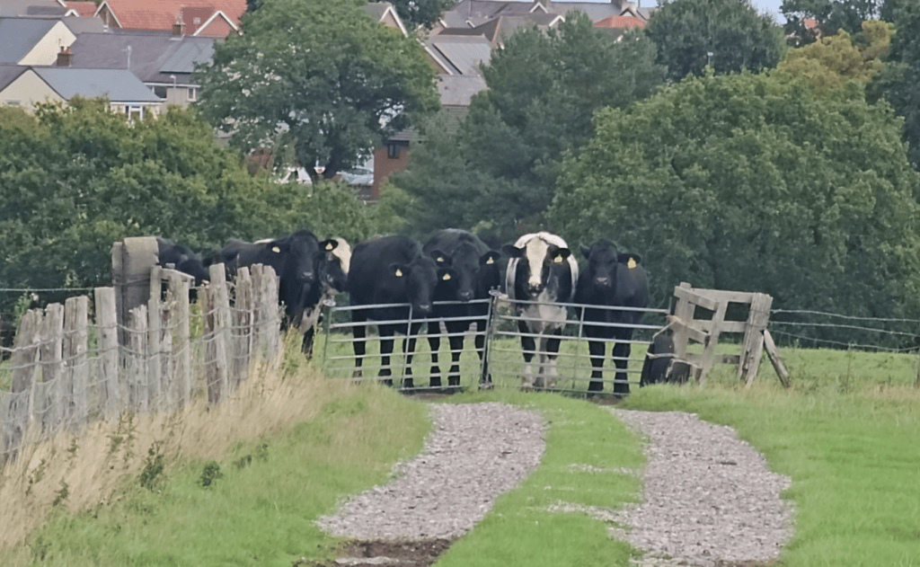
My stealth and agility were tested again when heading away from the Expressway through a short stretch of fields. One of them had a legion of cows clustered right on the path, in front of the gate I needed to exit the field through. As I got closer to them they made it clear to me that they were not going to let me pass through them without aggro. There’s a sort of ‘I’m standing my ground’ gesture they do with their foot and I wasn’t going to argue with them once I saw one deploy it. I had to do some tricky manoeuvres involving hoisting my circa 15kg pack over barbwire-topped fencing, in order to get safely around them.

Shortly afterwards, the footpath here took a neat route right through the farmyard’s cowshed and I got to safely discuss the incident with a couple of the residents as I passed through.

Cows and Ways and Blackberr-ays

I skirted the edges of the village of Sychdyn and, despite the ibuprofen-muted blister pain, was enjoying the sunny September day, and the pleasant country lane I was walking down, nicking the odd blackberry from the bushes.

Throughout the trip, where I saw clumps blackberries hanging over paths and lanes, there were plenty that seemed to have both fruited early and then been scorched to death by the summer’s apocalyptic sun. The last time I’d been in Wales, I’d traversed the Carneddau over two days, camping on Carnedd Llewellyn – my first hike in Snowdonia and my first camp at over 1000 meters. It was one of the best experiences of my life and the views were, of course, incredible. But the sense of something being desperately wrong was woven through all of it.

Gazing down from 1064 meters over the expanse of yellowed countryside below was frightening and heartbreaking as it was breathtaking. Descending from the mountains the heat was back in the high-normal zone for Summer, pretty uncomfortable for hiking. As I sweltered along the path to Conwy, I came right up to the scorched hills that had been blazing above the town just a couple of weeks before. I’ve seen post-wildfire moorlands before – the bleak devastation, the charred-black soil and the skeletonised shrubs. Here, in the heat, after the summer had reset expectations about how bad things could get, and how quickly, it felt ugly in a new way.

But wherever the good blackberries still hung, I gratefully took advantage. Plenty of damsons about too.

I crossed over the River Alyn and then Denbigh Road, and found the small road branching towards Gwernaffield, which should take me most of the way to Moel Famau’s foot. I was a little concerned to note the ‘Road Closed’ signs at its mouth. But I’d had a great walk up to the top of Snake Pass earlier this year, when it was closed to traffic for repairs, with pedestrians still free to roam – I was hoping this would be a similar deal. But this notion was rapidly squished by the massive building site that came into view. A large housing estate was being built over the road and the fields surrounding it. It was an expansive development with no obvious way around; I hunted for an alternative route on foot, but just found myself back at the construction site’s vast perimeter. Morosely checking between the Hiiker app and Google Maps, there didn’t seem to be anything else to do but take a hefty diversion back up Denbigh Road and up through Rhydymwyn.

This was a grim and unwelcome extension of the journey. Denbigh Road, the A541, is a hideously fast two laner and as it approaches Rhydymwyn its pavement disappears and it becomes more like a country road. But the traffic there is still hurtling and hasn’t yet picked up that country lane sensibility – the sensibility where drivers are aware that a fal-de-dee fucker like myself might be wandering along it. The last pavementless mile or so was horrible and I was grateful to get to the safety of Rhydymwyn. I popped into a service station to grab something for lunch and got myself a massive ‘Oggie’, a pasty the size and heft of a sleeping cat.

I found a bench and devoured the Oggie. The bench just happened to be in sight of two commemorative plaques. One noted the town’s crucial role in the development and storage of mustard gas, and its contribution to the research that led to the development of the atomic bomb. The other reported that Felix Mendelssohn had written ‘The Rivulet’ here. So swings and roundabouts I suppose.

A rest at Rhydymwyn

Somewhat fortified I headed out of the surprisingly violent and musical village of Rhydymwyn along a single track asphalt lane called Nant Alyn Road. The route then directed me into some woodland to follow a path running in parallel to the road, along the side of a dried-up river bed. After getting a few yards it was clear that this path had not been used by a human for maybe decades. I should have quit with that realisation, but I can struggle to make sensible decisions sometimes, especially where the choice is between ‘forging ahead’ and ‘turning back’. The overgrowth intensified to the point where I was getting badly scratched and I was having to really bully my way through the plants to make any progress. It was the kind of situation where you have to pick your knees up comically high to avoid getting snared by brambles, then stamp down as much vegetation as possible in order to clear a way for the next step. This was ridiculous and I knew I’d been dumb to get so deep into something that looked obviously unpromising from the outset. I wanted a machete.

Checking the map I could see that I was still only a few yards away from Nant Alyn Road and I wanted so badly to be back upon its gleaming, vegetation-free asphalt. So I re-oriented my thrashing trudge north and managed to hack a way through to the rocky, dried-up river bed, then up the steep embankment leading to the refuge of the road. I emerged from the dense hedges lining the lane in a bleeding, dishevelled heap, as I did so a passing jogger spotted me and said ‘nice to see you again’!

I took off my rucksack to make some adjustments and my bottle of electrolyted water popped out of its pocket and skidded some way back down the slope. Theoretically I could leave it as I’d be passing through settlements that looked large enough to have a shop, and I had water purification tablets in case I had to rely on a stream or something. But still, if I don’t retrieve it, it will be both litter and another thing lost on the trip. I manage to get it by part dangling myself back over the slope and hooking it awkwardly up to my level using my hiking pole. Right. Now I can get on with the very simple job of walking up this road, the molehill that I’ve made a mountain out of.

Nant Alyn Misadventure

Hoping that the day’s quota of unnecessary drama was behind me now, I followed the Road and a further series of gorgeous green lanes to the village of Cilcain. I had a chat with a guy who was stood affably directing traffic. He used to be an avid hiker until his knees became too painful. Great guy.

I’m not sure how it would have been from the perspective of the original planned route, but this diversion via Cilcain had given me a great approach to the foot of Moel Famau. I got to watch it grow steadily, able to make out with crystal clarity the stone structure of the Jubilee Tower at its top.

Laneside Peeks

After a while I was on a rising path, but wasn’t exactly sure I’d begun climbing Moel Famau. Psychologically, I didn’t want to prematurely believe that I’d started the journey’s final ascent, in case I found there was a further deep, demoralising valley to negotiate first. Soon enough it was clear that I was actually on the hill itself; I could make out that I had a couple of pretty steep stretches to navigate and I steeled myself for the effort, hoping that there wasn’t anything too sketchy ahead. It was steep indeed, but not scrambly and the rapid rise in elevation meant that the views began opening up and becoming spectacular.

I crossed over a path at the end of what looked on the map to have been the steepest section and then almost immediately I could see the Jubilee Tower at the top of the path ahead – I cackled with surprise as I’d assumed I still had much further to go. But no – there it was about half a mile ahead.

I got to the foot of the Tower – it’s actually a base for a much taller structure, whose construction was abandoned, with much of its stone then plundered for drystone walls. It now survives, crowning the hill as a grand ruin and perfect viewing platform – and you can see it from my flat, 48 miles away.

Ascending Moel Famau

As the crow flies, of course. I hauled myself up the structure’s great stone steps and made my way to its top, to complete my 81 mile journey (minus the bit in the taxi). It was fairly busy with Saturday walkers taking in its incredible vistas. A woman was in the prime spot for getting pictures and I hung back waiting until she was done. She detected me waiting and made space for me – I said ‘are you sure you got all the pictures you wanted to?’ and she said ‘Oh yes. By the way, I’ve seen you up here before!’ I asked her if she was sure, because I’d only been up here once before – just over a year ago, in fact. But she was certain she’d indeed seen me up here and was convinced enough to convince me of it too, as unlikely as it seemed. I guess I’ve either got a doppleganger, or this is one heckuva coincidence.

I couldn’t have been more aware of where I was, given the fact that I’d been thinking about this walk in some form or other for the best part of ten years, and that I was now exactly at the point that every painful step of this journey had been leading towards. Nevertheless, I was completely disorientated. I was fumbling between competing, important-seeming tasks – take pictures, make videos, think of something suitably profound to say about getting here; try and find the exact direction that points home, find Alderman’s Hill, drink water, eat something!

I tried to find the precise line which pointed home, but I couldn’t quite concentrate enough to do it in a way that erased all doubt. And so I just gazed at the hazy line which was probably the horizon I’d walked from, and tried to take in how I’d got from there to here.

And then let myself wallow in the rest of the views that are presented to you on top of Moel Famau. There are so many landscapes and landmarks visible, the drama of Snowdonia and the Carneddau where I’d walked back at the end of July; the gentle, green Clywidian range, the Wirral, the Mersey Estuary, Liverpool, Runcorn Bridge, Stanlow Oil Refinery, the Mid-Cheshire Ridge – Jodrell Bank is visible beyond it too today.

Seeing things on Moel Famau

It’s not a crisp, clear day though. There’s a haziness to it all and it feels like this contributes to my inability to get a grip on how I’m supposed to feel about being here. I’m glad to have made it. And I’m moved by all the beauty I can see. I think that feeling all the things you’d like to, on cue, when you’re at a moment like this, is probably asking a bit too much.

Then I realise – I don’t have to walk anywhere tomorrow! That actually feels fantastic. I have a snack and the last of the electrolyted water I rescued earlier in the day and head down off the hill.