Day 2 – Combs Valley Campsite to Kinder Downfall

Combs Valley Camp Site, Eccles Pike, Chinley Churn, Mount Famine, South Head, Brown Knoll, Kinder Low. 13.5 miles.

I’m on Kinder, back from the edge sheltered from the wind by large hags and on ground that hopefully won’t saturate if there’s heavy rain tonight. Currently it’s pretty still but anything can happen up here. My altimeter app says I’m at 566 meters.

Today began with a trudge out of Combs up Eccles Pike. It’s a relatively small hill but forms an almost perfect triangular lump on the horizon. I took the zoomed-in portrait of Manchester and looked at the other hills I would be ascending today.

Though a shorter walk in miles and with less overall ascent and descent this was going to feel pretty strenuous. There weren’t many sections which felt like a pleasant strolling out of the miles – it seemed to be all trudging up or tottering down steep angles.

At the base of the ascent to Chinley Churn the A6 divides a footpath seemingly never used judging by the growth around the sign.

The dark overgrown path brought me out at the back of an industrial estate before sending me over a stream and under a railway bridge into Brierley Green. From there it was up an interminable series of steep fields to the base of Chinley Churn. One of the fields smelled breathtakingly foul. It was churned up with hoofprints and so I blamed the horses, but I was shocked they’d produced something so impressive. At the top of the series of fields – after the path suddenly gentrified as it passed through a well tended and monied-looking garden – I found a couple having a breather. They said they needed to find a way down, but wanted to avoid the field below as the farmer had filled it with slurry. Ah.

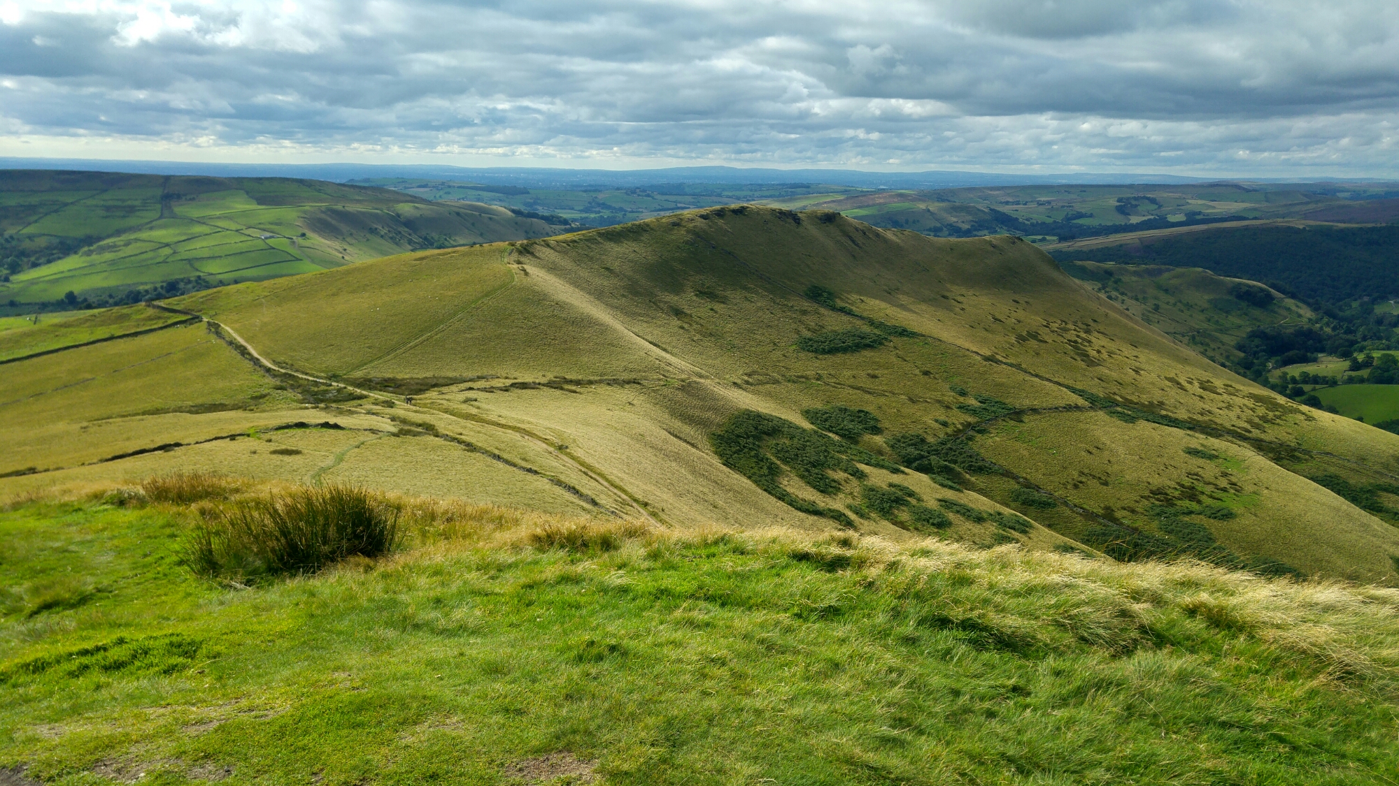
Chinley Churn is really huge. It’s got quarries, gritstone edges – various areas of rocky, lumpy interest. And lots of fields which are saddled over its walled-off summit.You have to scale a drystone wall or two to get to it, but its views over Manchester are splendid.

It had taken a lot out of me getting up there and the scale of the scaling yet to be done before pitching up today was starting to get me worried. I could take this adventure at my own pace, but with the stashes waiting at certain points on the route, things could start getting tricky nutrition and water-wise if I don’t get where I planned to each day. This has meant a little anxiousness on both days so far about whether I’d really make the distance or if I’d have to pitch up short of my target. It’s unfortunate to have deadlines on this… there is quite a jolt of euphoria though when I do realise I’m going to make it, but at the top of Chinley Churn I still had a lot of climbing to do and really wasn’t certain I’d get here.

It was heartening to discover my stash uneaten in the roadside thicket we’d left it in last Wednesday. The extra weight of it though felt like a bit of a self-kicking at this point, with so much more climbing to do. But I made it up Mount Famine and South Head – confirmed that South Head is indeed visible from home – and then got through the long slow trudge up to Brown Knoll. This is the last visible lump from Lamport Court before another block of flats hides everything from there to Bleaklow. I’m in the shadow of Silkin Court now until I break out into Lamport light again after a few miles tomorrow.

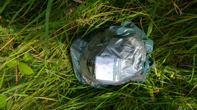
As I got to Kinder there were mountain rescue teams hovering in a helicopter over edge and waiting in jeeps on a path below Edale Rocks. Later, as I got closer to Kinder Low, someone’s rucksack was weighed down with a rock leaning on a cairn. I hope they’re okay.

My mind and my legs were starting to sputter to a halt as I got close to Kinder Downfall – I realised I needed to pitch up at any suitable spot while I could still think straight. I dragged my legs up away from the edge onto the periphery of Kinder’s hag and grough interior and found a relatively windless spot. It took a couple of goes and a bit of adjustment to avoid squelchy ground but I think it’s going to be okay here.

Day 1 – Sutton Moor BT tower to Combs Valley Camp Site

Croker Hill, Shuttlingsloe, Shining Tor, Cat’s Tor, Combs Moss. 19 Miles.

I’ve been given a beer by a gregarious couple out doing their regular camping thing but this time doing it with their daughters in tow. I’m zipped up in my tent listening to them have their holiday. I think they’d have liked to hang out but I was only fit to cook my dinner and take off my boots and write this. They seem really great, though and I wish I could remember their names.

This campsite is right next to a railway line. Every now and then a horse screams.

The BT tower at Croker Hill – sentinel of the start of the walk – barely bothered to turn up for the event. This tower has always looked like the start, to me, of the high ground around Manchester. Alderly Edge just won’t stick to my mind. It doesn’t belong in here. There’s something a little further out – Hen Cloud or just ‘The Cloud’ – which forms a continuing bump after it from the perspective of the city centre, but it was always going to be Croker Hill/Sutton Moor with its great tower that was going to be the start.

Fogged into near-nothingness we almost missed it as Rachel tentatively rolled us over the narrow PRIVATE track that leads up to its nest. We said goodbyes and I set off, fading out into the blank at the end of 10 yards of path.

I was off down a muddy field and after a few minutes the cloud began to thin out and pockets of the surrounding landscape were revealed. Jodrell Bank was gleaming and Manchester started to get some definition and glow.

This was the plan working already – to be on the horizon looking back.

The White Peak area of the Peak District is mostly less high and feels mostly more genteel and tamed than the Dark Peak above it. Less dramatic – frendlier greens. The people abroad on it seem ‘comfortable’ – things are working out for them and the landscape is for their healthy pleasure. A stunning flock of joggers ‘morning’-ed me as I sat recovering halfway up a clough. A guy scrambled down a stream to ask me if there was anything of ‘interest’ down the slope i’d just ascended. ‘It depends what you’re into’, I told him. The valleys and peaks were looking idyllic today in the sun.

I made my way over fields and through Macclesfield Forest up on to the peak of Shuttlingsloe. From there I plunged into the valley and the village of Wildboarclough (I think there are a few places in the UK which claim to have hosted the last wild boar in the land and this is one) passed through a farmyard with some terrifying dogs on taut tethers and then slogged up through Cumberland Clough to the Cat and Fiddle and then to Cheshire’s highest peak Shining Tor.

From there I could see the bulk of the Dark Peak, looking all wild and handsome, and I could pick out the individual hills I’d be struggling with tomorrow – Eccles Pike, Chinley Churn, Mount Famine, South Head, Brown Knoll and Kinder Scout – where I’d hopefully find a spot to camp.

At each of the peaks and prominent places I get to I’m  going to be taking a zoomed in picture of Manchester – locating where my flat is using the Beetham tower and the CIS tower as guides to where I should be pointing at. I’ll then have a kind of record of how it looks as the horizon looks back at me.

From Shining Tor I stayed with the city to my left as I made it to it’s smaller sister peak Cat’s Tor. I had lunch and watched some model plane enthusiasts get thwarted by the too-strong wind. Then steeply down into the Goyt Valley and by its reservoirs a measure of disappointment because its public toilets were out of order. Shit.

The steepest and toughest climb of the lot today was from the Goyt valley to the northwestern tip of Combs Moss. I was seriously fatigued and starting to get a little worried about making it to the campsite. I was also worried about getting up on this big slab of land – the route hadn’t seemed clear either on Google Earth or the OS map. Thankfully I found an access path which took me legally to the top without me having to scale any walls or barbed wire fences – mentally too much of a task this late in the day. Getting to the top I could finally confirm that the land I could see from home poking out of either side of Whaley Moor was indeed Combs Moss. This was such a pleasing moment – I’d confirmed the last bit of the horizon I’d been uncertain about. I took my picture of home and made my way around its fine, mini-Kinder-Scout-like edges.

I met a guy picking berries – he was still eating last year’s massive hoard from the freezer – who pointed me in the right direction for the campsite at the bottom of the valley. I tiredly went the other way and he came bounding after across half a mile of steep field to set me straight. Cheers Dave – may you never run out of wimberries.

I made it to the campsite with enough time to pitch up and cook before sunset. I’m pretty amazed I made it this far. It’s less miles tomorrow – just 13, so hopefully a less arduous day.